|
SoarWest Pages:
Soaring
Soaring Photos
Soaring Sites
Soaring Events
Panoramas
R/C Soaring
R/C Photos
R/C Soaring Sites
R/C For Sale
R/C Clubs
IMSF
Soar Utah '98
Soaring Clubs
Utah Soaring Assoc.
Utah State Records
Links, Search, Misc
Links and more
Portfolio Photos
Soaring WebRing
Search SoarWest
Changes

| |
R/C Soaring Sites in and around Utah
To read articles discussing some Utah sites which were
written for previous IMSF newsletters, see the R/C Stories
page. Be published: write your own site review with directions for any site in the
Western US, send it to admin@soarwest.com and it
will get published here.
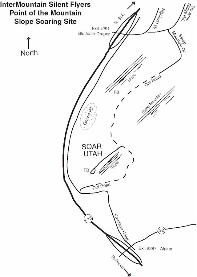
- Point of the Mountain, Salt Lake Valley Utah
 |
The Point of the Mountain is an incredible
soaring site. It's an ancient natural sand peninsula between the Salt Lake and Utah
valleys. From I-15, you can take the exit on either side of the point, head towards it and
you will get there. We share the site with hang
gliders and parasails so fly with caution.
Click on the map to see a larger one. |
From the South
Take the Alpine exit #287, just south of the point.
Head East, then turn immediately North onto the frontage road. Just as the frontage
road nears the freeway again, there is a sign which says "Point of the Mountain
soaring site, Utah Hang Glider Association". Turn right onto the dirt road and
follow it up to the top of the bench. At the top turn left and you will be at the
south side soaring site. To get to the north side, continue on the same road as it
only goes directly to the north side soaring site.
From the North
Take the Bluffdale/Draper exit #291, just north of the
point. Head South East, continue thru the 4 way stop on Highland Dr. Turn right onto
Traverse Ridge Rd and then right again on Steep Mountain Drive. Stay on Steep Mountain
Drive until it turns into a dirt road and you're there. It is adjacent to the last
few homes on the hill.
IMSF Club Field in Kearns Utah
The club field for thermal contests is located behind a
school in a park at:
5600 South Sara Jane Drive (5240 West) Kearns, Utah
To get there, take I-215 to the 4700 South exit. Thru
West and continue to the Bangerter Highway. Turn South (left) on Bangerter Highway
and continue to 5400 South. Turn West (right) and continue to 5240 West. Turn
left into the sub-division. After the 4-way stop sign, when you see the school on
your left, turn in and right to the parking lot. We fly off the sloping hill behind
the baseball diamonds.
If you live where you have access to the Bangerter Highway,
you can get on it and drive directly to 5400 South, then continue as above.
Francis Peak, Farmington Utah
I haven't flown here yet, though I have seen the site from
the valley, and the R/C Photo page shows some pictures from the
top. It's on a mountain behind Farmington and the Lagoon amusement park. I
have been told that if you drive around behind Lagoon in the canyon to the NE, you will
eventually find the road that leads to the top. I will try to get better directions.
Rush Valley Dry Lake Bed, Utah
This is a small dry lake bed in a valley west of Utah
Valley and South East of Toele. It's an incredible thermal field in the summer but
it can be hot. If you ever need to fly for hours and hours due to thermal lift, this
is the place to go. It's on the pony express trail and about 45-minutes from the
Point.
To get there, take I-15 to the Lehi Roller Mills exit and
head west through town. Keep going and the road turns into a highway. As you
pass the end of redwood road, you are heading up to Cedar Pass Ranch. You continue
past the Cedar Valley airport and on through Cedar Valley, continue through this
valley to the next pass. Just at the peak of the pass, at the off-road recreation
area is a turn off heading WSW. There is a pony express trail sign. Take this
exit and head out. In about 7 miles at the bottom of the Rush valley, you will see a
Pony Express monument on your right. Turn here and head past the monument on a small
dirt trail for about a mile. It's a 900'x500' smooth lake bed. Great for
soaring and all kinds of powered flight that requires and incredible runway.
Squaw Peak, Utah Valley Utah
This site is only good on days when then winds are out of
the South to South West. It's got a great view (very popular at night with the
dating scene), and fun flying... but, not much in the way of a landing area. You
need to have a hardy slope plane you can land in a "soft" bush to be able to
comfortably fly here.
Tower Mountain, SE of Heber Valley Utah
This is the site were a few friends and I are flying in the
High Uinta's on the R/C Photo page. You won't be able to
get to this site until mid summer as it's about 10,000' high on a dirt road and you will
need to wait for the snow to melt.
To get there, go to Heber City, at 100 North where the
First Security Bank is, turn East and head up the canyon. In about 8-9 miles the pavement
ends and you are heading up the canyon into the National Forest. After probably 10 miles
of dirt road, you will end up in a pass with a sign pointing several ways you can go down
several canyons (the sign shows the elevation as 9990 and says 19 miles to Heber). To the
South West you will see the hill, with a radio tower on it. If you turn South (right), in
about a half mile there is a road that goes to the top of the hill. You can park by the
radio shack and then select the side of the hill to fly on depending on the winds at the
current time. Generally the winds are from the South West as shown in the pictures. Those
pictures were taken in August and you can see there was still snow up there, it may be
late in the year before you can get there to actually fly. Once you do, it is well worth
the drive as the experience is just incredible!
Directions verified summer 1998.
Jackson Hole, Wyoming
Thanks to Paul
Brabenec for this site review. 09July1998
On the southwest outskirts of the town of Jackson, Wyoming stands a butte 670 feet tall
with excellent slope soaring to the west, SW, south,and SE, I believe called Miller Butte.
Prevailing winds are SW, across flat valley floor and onto a smooth, treeless slope of
about 34 degrees. The south slope is steeper, rougher, and sparsely forested. The
west slope is lower angled with a slight bowled shape with about a 1/3-mile width.
There is a good-sized grassy field at the southwest foot of the butte and across a
street. I've flown large sailplanes on the slope while walking down to the field and
then brought the plane down to land at my feet, avoiding trying to land a big sailplane up
on the slope.We've seen schoolkids flying off
highstarts in the field and have a report of a radio-interference caused crash (there is
no organized frequency control). I've soared here into the sunset often and the
place is quite reliable in the evening. Sometimes paragliders practice sled-ride
flights to the grassy field mentioned. As far as I know, this is public land, I think a
school section, maybe. There is a small subdivision at the foot of the west face but you
have to get out pretty far to be over it.
Anyway, I wanted to suggest this flying opportunity to any
of you coming up this way. To get to this slope, coming into Jackson from the south
on US89, turn left (west) at the first stoplight (High School Rd). Go to the first
stopsign (Wildflower Ct) and turn right (north). You'll be looking at the south face of
the butte. Follow around in front of the Middle School and you can park in the
school lot right at the foot of the butte, with a footpath to the top directly across the
street.
Reno Nevada R/C Soaring Sites
www.scrollsander.com
under Soaring goodies has info and maps for soaring sites in the Reno area.

This page was updated Monday, June 14, 2004.
|